
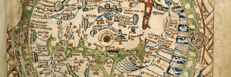
The Psalter World Map of the 13th Century: Unveiling mysteries of the medieval world.
The Psalter World Map, a medieval marvel, intertwines art, faith, and geography, offering a unique window into the medieval worldview.
CHART & COMPASS, SEXTANT AND SUN-DIAL, LATITUTUDES AND LONGTITUDES, PLUMBLINE & PENDULUM, GLOBE OR PLANE?
A LETTER OF REMONSTRANCE
RESPECTFULLY ADDRESSED TO THK OFFICERS OF THE NAVAL AND MERCANTILE MARINE OF GREAT BRITAIN AND AMERICA.
This letter was sent in 1887 from the Secretary of the Zetetic Society to Officers
Gentlemen,
At a time when naval men and shipowners are beginning to inquire whether the science of navigation, with its collateral conditions, is not susceptible of some measure of improvement, may we venture to draw your attention to the undeniable fact that they are still using a projection or Chart of the World which was invented three centuries ago, and which has never been considered otherwise than a make-shift, and retained only because there was no accurate knowledge of the ocean’s surface or its configuration. But this ignorance is hardly creditable in the present condition of our commercial interests and the extent of our foreign and colonial traffic.
If those whom it may concern are really in earnest when they propose to take into consideration any means that may be suggested for affording greater security in ocean travelling, and leave them less dependent on systems of navigation which may have been considered efficient for coasting purposes, or before our colonial empire was so extensive as it it now, they will, I trust, be willing to admit that not merely the substantial construction of the vessels themselves should be practically considered, but shipowners and naval men generally should honestly and intelligently ascertain how far their existing charts and projections may be regarded as incapable of improvement, or be practically relied on as affording the most accurate information as to distances and relative position of every principal spot on the navigable ocean.
Without any reference to existing theories, may we venture to ask how many of our most experienced seamen and naval officers could say if they knew what was the actual difference between the northern and southern meridians of longitude ? Would they not be obliged to confess that they were navigating their ships on an artificial or purely conjectural system of hydrography, and that the training they had received had never taken into account the possibility of there being a more simple and far more rational method of navigation by a stricter adherence to demonstrable facts instead of to artificial rules and astronomical principles, which can have no more analogy to terrestrial or water surfaces than there could be between the length of a ship’s deck and the date of the owner’s birth.
If their system was as correct as it professes to be, ought not a fully trained and perfectly educated officer be able to take a ship, say, to Malta and back, on second or third voyage? Instead of which, when his theoretical education is over, he has to put his theories in his sea chest and learn from actual observation, for many long years, how to take a vessel, say, to the Cape of Good Hope, without finding himself, some foggy morning, on the coast of Mexico ? We are afraid these remarks will be received with much disfavour, and be resented as an insult to the services they are humbly intended to serve. But we are sure the issues are too serious to admit of any palliation, even in spite of the undeniable fact that thousands of vessels every year find their way out and home again with the most infallible accuracy. But is this any justification for retaining a system which has to be supplemented with the most voluminous tables, and practically ignored by every experienced sailor?
We are merely insisting on the fact that a comparatively perfect projection is as easy of construction, and a thousand times more intelligible, than one which makes a burlesque of the whole subject, and is as unlike what it is intended to represent as if concocted by a village schoolboy. Whether the earth be a globe or a plane, a square chart, with its rectangular meridians, cannot possibly represent its natural divisions, or define its relative distances, or give the true position of its several continents, or the actual bearing of any spot out of sight of the “crow’s nest.” Any accuracy of detail is utterly impossible under such theoretical conditions.
Surely no one will venture to say that this unnecessary and inexcusable defect in one of the most essential elements of practical navigation is not a slur on two great maritime nations like England and America ? I f other countries are no wiser, is that any reason why we should persist in setting such an example of barbarous ignorance ? Our Admiralty and Boards of Trade are, unfortunately, regarded as oracular on all subjects relating to seamanship and naval science. We are, therefore, the more inexcusable for encouraging others to retain what we dare not defend in our own principles.
We are ashamed to have to insist that the proper construction of our charts of the habitable world is as easily determined, and the distances as accurately laid down, and the latitudes and longitudes as mathematically infallible, as would be the plan of an estate of a few hundred acres. And yet, in this professedly most enlightened age, we’re still using a square chart, with every figure and line of it wrong, and as unlike the real earth and its waters as the ingenuity of man could conceive! Is not such ignorance as pitiable in our case as when the Ninevites were said not to know their right hand from their left ?
The distances on Mercator’s chart are computed on the arc measurement, when no such shape as ‘a curve can anywhere be
found ! So there are not 90 degrees north or south of the Equator, but only 57.5 degrees ; barely 45 degrees of which are practically
navigable ! Meridians of longitude cannot possibly be parallel, but must be divergent from the central north to the southern circumference. Mercator’s straight edge is as preposterous as a South Polar centre!
But, without pursuing this subject further, we are quite prepared to show that the topography of the circular plane on which we live, admits of exactly the same infallible accuracy as the compilation of the multiplication table.
By using the present imperfect and most misleading projections, ships must inevitably wander hundreds of miles out of their direct courses ; while time and money and valuable cargoes are often risked, merely because the authorities at home think they would forfeit a certain amount of prestige by abandoning their time honoured fallacies.
If the Royal Geographical Societies of England, Scotland, and Ireland cannot give you better instructions, on what grounds, it may be asked, do these scientific Associations venture to collect incomes of £6,000 or £8,000 a year each and obtain royal charters for diffusing imposture and fraud and fiction ?
Now let us make a few practical remarks on the quadrant and sun-dial. From models or specimens now to be seen in the British Museum, we learn that the quadrant was known and used so early as the end of the 14th century, or several hundred years before sailors ever dreamed they were sailing on the surface of a spherical ocean. The inventor, therefore, never contemplated its employment otherwise than on an horizontal base, at right angles to the sun’s vertical rays or to the perpendicular of any other distant object; and it can, by no possibility, give a true elevation, if used on any other conditions! If these absolute conditions are not practically complied with, the observers would have three-fourths of their time occupied in making allowance for “curvature” which it is well known they are never insane enough to think of.
Again, all observers arc supposed to be on one and the same horizontal base, so that a greater angle than 90 degrees is never contemplated or provided for or obtainable in any survey that can be made!
Every arctic explorer knows that in the latitude, say, of Behring’s Straits, or Hudson’s Bay, an observation of the sun can be made at midnight, looking due north; which would be physically impossible if a large segment of a circle intervened between the observer and the June solstice; looking over the North “Pole !”
How discreditable it is to two such maritime nations as England and America, to say nothing of the other European governments, that such gross and wholly inexcusable ignorance on some of the most important points and the most elementary conditions in navigation should still prevail!
Again, we do not believe that there is one nautical man in ten thousand who knows the true cause of the compass needle’s pointing north and south! Unless our naval instructors are no wiser themselves, their sole object seems to be to allow our seamen and officers to be mere machines, and, like the children of landsmen, to be unacquainted with the most rudimentary principles and conditions of practical science. An exposure inevitably
will take place some day ; and the professors will then learn a lesson from their ill-instructed dupes they are not likely to forget.
The English press, both secular and religious, is unfortunately in the hands of those who are as ignorant of the genuine facts of science as the most thoughtless of their readers. And to hide their shameful incapacity, they toady, like brainless sycophants to the professional authorities, who like abject cowards allow these half-witted journalists to display their wisdom by burking all open discussion, and publishing their vulgar sneers when any honest inquirer ventures to refer to the subject.
We could fill many pages with the description of the manifold fallacies in connection with some of the most familiar objects around us. Phenomena and facts are daily taking place before our eyes, while’ we go on, year. after year, and age after age, as ignorant of their true character as if no such things had ever been seen. Even men of the most undoubted intelligence have, for example, gone on for the last 150 years using a ship’s quadrant, and never pausing to inquire or to perceive that the instrument was utterly incapable of being accommodated to the conditions they supposed to ex ist!
Another instrument, quite as familiar as that of the quadrant or sextant, is the sun-dial. It is the very oldest philosophical instrument ever used or invented by man. And for more than 5,000 years it was used in all its simplicity and perfection of principle ; that is, on the motionless disc of a stationary earth, with a revolving sun to mark the shadows in its daily progress, or circular orbit, from its rising to its setting.
But, for the last 200 years, a set of crafty, and fraudulent, and infidel professors have dared to assure their dupes that the sextant and the sun-dial could be as easily used on a round and revolving globe, as on a circular and motionless plane! And, in the ignorance and credulity of our childhood, we have been led to accept as genuine truth some of the most degrading and senseless superstitions ever devised by the arch-fiend himself, in order to persuade mankind that they were wiser than God, and had far sounder views of his creation.
We have scores of other facts, quite as palpable and important, but we forbear, and only ask our readers to weigh well what we
have already stated.
Mr. Jordan, of 81, Spring Street, Hull, will send a lithographed sketch of the true and false application of the sextant, which lie was the first to detect.
The inutility of a sun-dial on a revolving globe will be apparent at a glance, when it is remembered that a body rotating on an axis, in one uniform plane before a fixed sun, must cast a straight shadow, east and west of any upright staff, placed anywhere or in any latitude between the solstices, so – Does it do so ?
Why not! Is it hardly credible that millions of intelligent men have used these two instruments during the last two centuries, without detecting the glaring absurdity of adapting them to the conditions of a round and revolving globe ?
And yet the very professors who have most fraudulently hidden these facts from us, have been year after year pocketing their enormous revenues, while leaving us to believe that all that science could reveal was honestly and instantly proclaimed for the benefit of those who have so unreservedly trusted them. And so far from exhibiting the commonest courtesy towards those who with every mark of respect sought to discuss the matter with
them, they have either refused to see them or have given them plainly to understand that no unprofessional assistance could be entertained for a moment.
The Secretary of the Zetetic Society will gladly furnish any further particulars on application.
We have left ourselves no room to refer at any length to the plumbline and pendulum. We have had, however, many opportunities of proving that they are both of them as fatal to the globular theory, as any of the other instruments we have mentioned. The plumbline has never been shown to deviate a hair’s breadth from a true perpendicular to any horizontal base. And as for the pendulum, its vagaries have as much consistency as a weathercock ! So that, literally, every possible test to which ingenuity can appeal—all of them, without one solitary exception, utterly refute the globular theory and fully establish the truth of the motionless plane, which the most learned and godly men maintained and taught for the first five thousand years. And the pagan blasphemy now insisted on in all our secular and religious literature has not the very ghost of a fact on which to rely,
Pythagoras, its original inventor, openly asserted that he had “spent six months in hell” and even if he had not told us so, we should know that there is but one source from whence such a system of lies, and imposture and blasphemy could have emanated.
Has it got one defender, except among the very scum of the literary world ? God’s bitterest curse must rest on any country and people enslaved by such heathen superstition. And, in spite of all the extravagant and senseless ecstasy now being displayed on the occasion of her Majesty’s Jubilee, we should have thought that after a fifty years’ slavery to such pernicious fallacies, and such worse than heathen ignorance on the most elementary subjects, we might have hoped that this year would have been characterised by some less childish and sensuous transports than those we are giving way to.
All communications to the Secretary, Zetetic Society, Cosmos Houses Balham, Surrey.
The only correct diagram of Latitudes and Longitudes and Solar courses ever published or procurable, with coloured Map of the World as a circular plane, may be had of the Secretary, Post free, 2s.
The Psalter World Map, a medieval marvel, intertwines art, faith, and geography, offering a unique window into the medieval worldview.
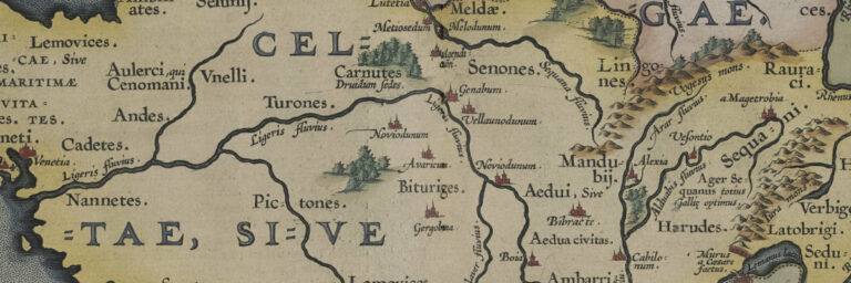
The Gallia Vetvs 1590 map is a historical masterpiece that depicts the ancient region of Gaul, which is now modern-day France. The map was created

Checking out Castles in Wales – a review of all the castles including ancient ruins with descriptions, prints and maps.