
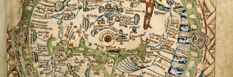
The Psalter World Map of the 13th Century: Unveiling mysteries of the medieval world.
The Psalter World Map, a medieval marvel, intertwines art, faith, and geography, offering a unique window into the medieval worldview.
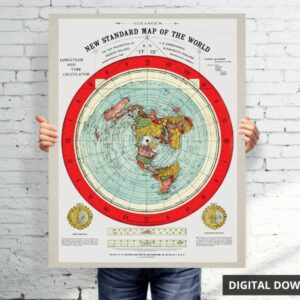
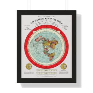
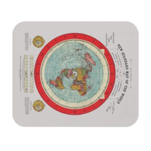
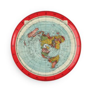
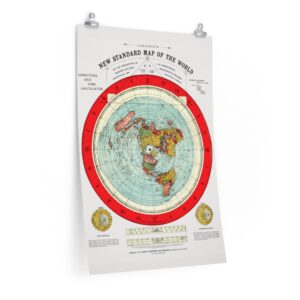
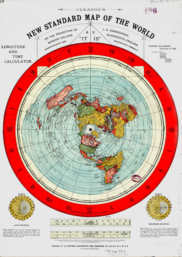
The Gleason’s map of 1892, revered by the “flat earth” community as a true representation of Earth, is a unique and rare world projection. This post aims to investigate the background of the map’s creators, Alexander Gleason and J.S. Christopher, and uncover the fascinating story behind the map’s creation.
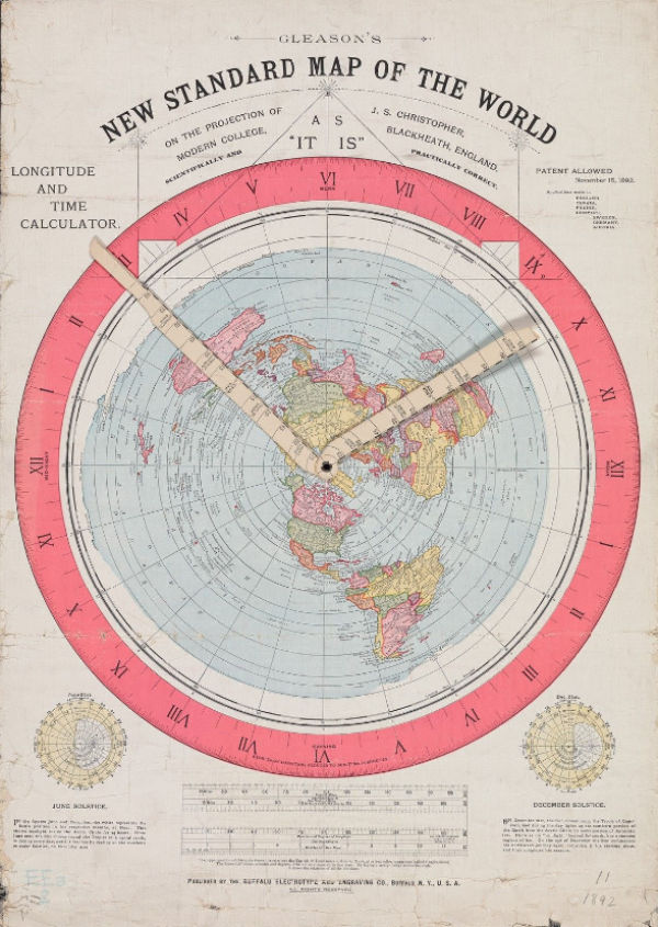
The Gleason map is notable for its indicator arms. These arms are integral to Gleason’s patent applications and serve a purpose we’ll explore later. For now, let’s start by examining Gleason’s own background story.
Born in the United States, Alexander “Alex” Gleason resided in Buffalo, New York. He is listed as an assigner to the Buffalo Electrotype and Engraving Company in patent applications.
Interestingly, Gleason’s 1892 map bears a key phrase on the back: “The demonstration has reference to either considerations: the earth a globe or a plane—take your choice.”
In his book, “Is the Bible from Heaven Heaven? Is the Earth a Globe?“, Gleason professed his religious beliefs as a Seventh Day Adventist. He fervently argued against the heliocentric model of Earth, citing a lack of evidence and conflict with Biblical scripture. His beliefs clearly aligned him with the “flat-earther” community.
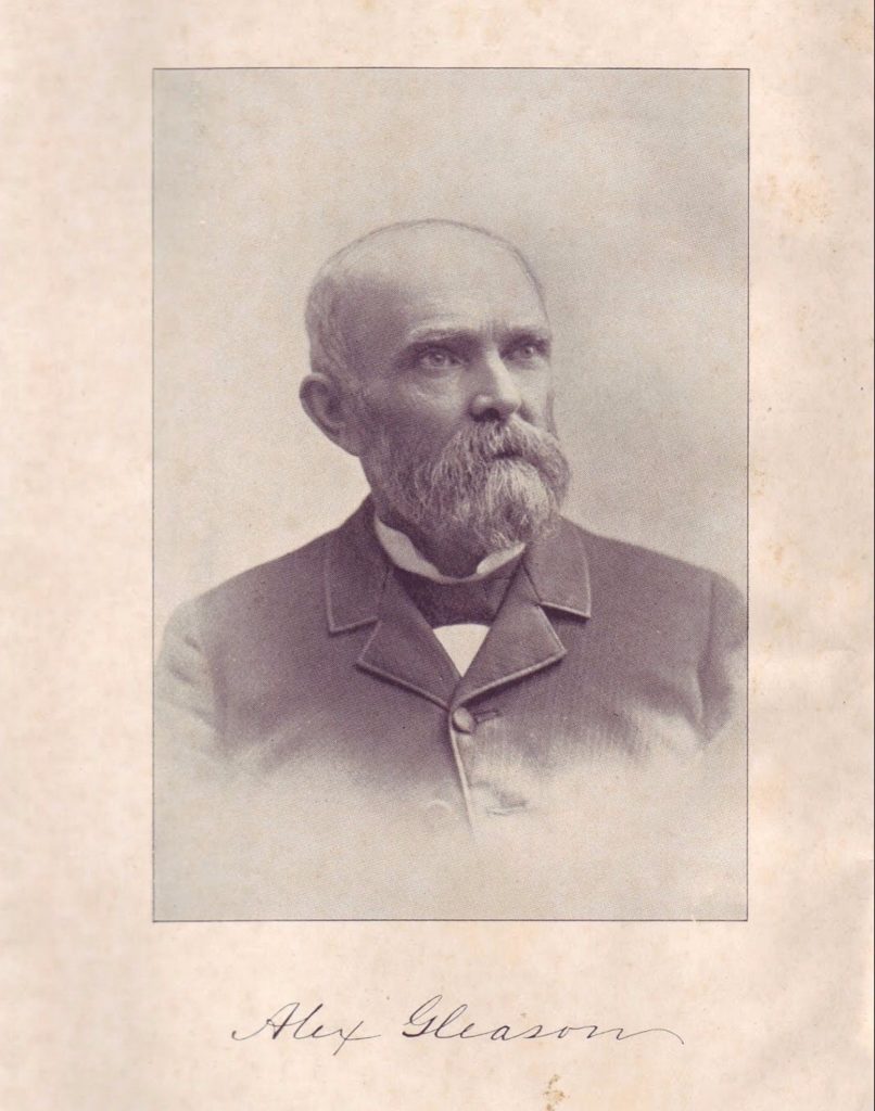
Gleason was born on November 28, 1827 – March 13, 1909, so was aged 65 years when releasing the map in 1892.
Gleason’s map and theories were not well received, especially in the local Buffalo press, which often lambasted his claims. Among the critics were publications like The Buffalo Commercial and Democrat (Wichita, KS), the latter even challenging Newton, Galileo, and Columbus’ theories in relation to Gleason’s propositions.
Is it any wonder that Alexander Gleason, of No. 1201 Niagara street, is making an effort to prove that the earth is flat? Nowadays nothing seems impossible to a Buffalonian. When Mr. Gleason has successfully demonstrated his theory in regard to our planet, he will doubtless take possession of the earth in the name of his native city. There was a time when Chicago waved the palm for greatest exhibition of municipal claims. The tide of empire, however, has begun to set eastward. Buffalo, the world is yours.
The Buffalo Commercial, 21 November1890 – https://www.newspapers.com/newspage/269473966/
Again there has arisen in our midst with bold attack upon the present system of astronomy and geodesy, a work of surpassing magnitude, by one Alexander Gleason of our own city, published by the Buffalo Electrotype and Engraving Co., and for sale by either of the above named. The work referred to bears the title of, “Is the Bible from Heaven?” “Is the earth a Globe?” While it is manifest from a moment’s glance that to the first interrogation there is no doubt in the mind of the writer as to the inspiration of the word; in regard to the second, if the diagrams and statistical measurements are correct; there remains some hard shelled nuts for our scientists to crack. At least profit might be gained to the most fastidious and sanguine by a careful perusal of the book.
The Buffalo Commercial, 24 March1893
Alexander Gleason, the sage of Niagara street, Buffalo, gave long and hard study to this great problem of the earth’s surface, and spent much money in publishing books and collecting information. At one time he advertised in a New York paper for sea captains who had made the trip from the West African coast around Cape Horn, his desire being to prove that the distance was much greater than it would be if the earth were a sphere. The information which he obtained seemed to be satisfactory to himself, though it not convince many scientists and geographers.
The principal arguments advanced by the flat earth theorists are that a ship might seem to sail around a ball when it merely sailed around a circle; that all the effects of day and night could be produced by a fixed sun shining down upon a circular earth revolving like a card on a pin, and that the longest rivers have a descent of only a few feet.
They say that the phenomenon at sea of the ship “rising” or disappearing is to be explained by refraction, and that if the earth were spherical the compass would not point north or south.
These theorists assert that Sir Isaac Newton was crazy, and Galileo and Columbus mistaken; that if the earth were a revolving globe, a projectile thrown vertically upward would not fall on the spot from which it was hurled.
And all of these propositions are backed up by copious quotations from the Bible, such as the four angles, at the four corners of the earth, the four winds of heaven, the angels that ascended and descended, etc. The underside of the earth having no sun is, say these dreamers, the place of darkness and damnation, and that it is reached only through the bottomless pit.
Democrat (Wichita, KS): 3, 20 Feb. 1897
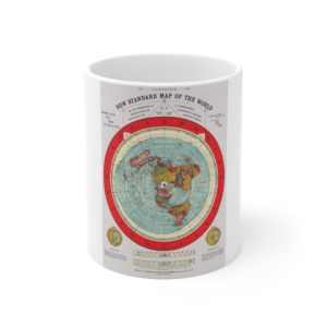
Gleason’s map bears a patent date of November 15, 1892, granted in the United States, with applications made in several other countries. It features two indicator hands that reflect a time chart, rather than a map, used to ascertain the time in any part of the world relative to your own meridian time.
Ref: https://patents.google.com/patent/US497917A/en
This work also declares the map as “AS IT IS” and “SCIENTIFICALLY AND PRACTICALLY CORRECT”. The projection is attributed to J.S. Christopher of Modern College, Blackheath, England, a supposed misspelling of “Morden College”.
At the top right hand corner of the map (Figure 1), it’s stated that a patent was granted on November 15, 1892. The patent was granted in the United States.
Other patent applications were made in England, Canada, France, Denmark, Sweden, Germany, and Austria. It’s unknown if any of these applications were granted.
The patent granted was for a mechanical device – a time chart, rather than a map. The two indicator hands (depicted in Figure 2) are used to ascertain the time of day or night, in any part of the world, corresponding to your own meridian time
Modern College, Blackheath, England doesn’t exist as a learning establishment. A cursory search indicates “Modern” is likely to be a mis-spelling of “Morden”. There is a “Morden College” in Blackheath. The establishment is currently a care home for the elderly.
If we are to presume Modern College on Gleason’s map equates to Morden college, the patent date matches a time in history when the college housed “decayed” merchants. Founder John Morden established the college to provide board, lodging and a pension for merchants who had fallen on hard times. Morden was an international trader and member of the Levant (Turkey) Company and the East India Company, returning to London in 1660 having amassed a substantial fortune.
Joseph Streep Christopher, the man behind the map projection, was a boarder at Morden College, a home for merchants who had fallen on hard times. While Christopher’s exact relationship with John Morden, the founder of the college, is unclear, their mutual involvement with the East India Company suggests a likely connection.
The researchers at Boston Rare Maps appear to have joined some of the dots
In any event, Joseph Steer Christopher was born in 1805 in Dartmouth, Devon; was a merchant active at the East India Chambers when he declared bankruptcy in 1844; was up and running with a railway investment scheme by 1845 and inviting investors in the “Natal Company” in 1850; lived for a time in Natal, South Africa and edited Natal, Cape of Good Hope (London: Effingham Wilson, 1850); is otherwise recorded at various addresses in England and Scotland; and from 1875 was resident at Morden College on Dec. 31, 1894, a home for “decayed merchants”.
Boston Rare Maps
It’s not clear if Christopher worked directly for John Morden, but as both were involved with the East India Company, so there is a good chance.
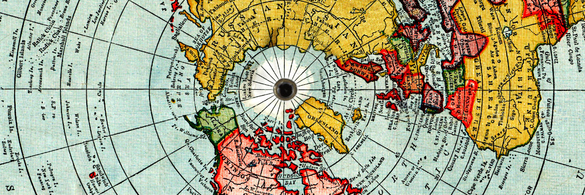
The Gleason map is a north-polar azimuthal equidistant projection with additional information on the June and December solstices. It depicts Antarctica as the outer rim and includes names of various locations in this outer Antarctic ring.
The map lists the following locations on the outer Antarctic ring:

Interestingly, the United Nations logo since 1946, features a similar projection to Gleason’s map, with the North Pole at the center. However, it omits Antarctica and instead includes laurel leaves symbolizing peace.
You can download Gleason’s Book from this website (free of charge) – Get Is the Bible from Heaven Heaven? Is the Earth a Globe? book in PDF format.
The Psalter World Map, a medieval marvel, intertwines art, faith, and geography, offering a unique window into the medieval worldview.
The Gallia Vetvs 1590 map is a historical masterpiece that depicts the ancient region of Gaul, which is now modern-day France. The map was created
Checking out Castles in Wales – a review of all the castles including ancient ruins with descriptions, prints and maps.